Showing posts with label infrastructure. Show all posts

Friday, October 12, 2012

Atlanta's first, um, contra-track-path thingy

The Fifth Street bicycle lane has been a valuable low-traffic connection between Midtown West/ Georgia Tech and Midtown East/ Virginia Highland/ Old Fourth Ward (and now the BeltLine). But there was always the tricky spot at one-way W. Peachtree St where Fifth jogged and you couldn't travel eastbound on it without going the wrong way or on the sidewalk for half a block. At one point, Tech had a driveway that made the connection, but they replaced it with a plaza...

Now, there is a new facility to address this problem. Cyclists continuing east on Fifth follow a ramp that takes them upstream so they are aligned with the next segment of the Fifth Street bike lane using a reallocated portion of the sidewalk. It is being referred to as a cycle track, although it is different from tracks I have seen - it is marked with paint rather than separated by curbing or pavement surface, and it is along the back of the sidewalk. But it does get you where you need to go.

For westbound traffic, I'm told there is now a "Copenhagen left turn" in which you stop beside the bike lane and wait for the green light on the cross street. I'm afraid I didn't see it as I had merged over to the left lane before my turn, as usual. Lanes are marked with green paint and directional arrows through the intersection. It is a pilot project, so city and state transportation departments will try to learn from its performance.


Wednesday, October 10, 2012

The BeltLine, or Atlanta grows a spine

The promise of the BeltLine started to come true last saturday. Although the eastside section of the path wasn't quite finished - entrances weren't paved and there was no lighting - it was open to the public during Atlanta Streets Alive.  As always, I was astounded by the latent bicycle culture that materializes anytime there are nice routes provided.

If you thought the only potential path riders in Atlanta were some spandex-clad athletes and maybe a few people with a cheap bike in the back of the garage, well, nothing could be further from the truth. Friends and families zipped along, going to restaurants, visiting neighbors, and finally stopping at the party at Ponce City East as it got dark. The bicycles rolling past me were as diverse and as stylish as the people riding them. I was with hope for the city's future.


Tuesday, September 18, 2012

Commerce Drive has a curb cut!

It's one of those small details you never notice until you are trying to navigate it by bicycle... The lack of a curb cut at the western junction of Commerce Dr and Freedom Path in Decatur meant that cyclists heading to this side of town either had to exit the path a 1/2 mile early, miss their turn, or jump their bike off a steep curb. This simple, inexpensive upgrade will do a lot for mobility in the corridor.

In the bigger picture, many transportation engineers are still trying to wrap their heads around the difference between a bicycle access point (basically a driveway) and a pedestrian access point which needs ADA accommodations. Not to mention the unique routing that bicycles need to re-enter the roadway correctly from a shared-use path.


Thursday, September 6, 2012

Quebec's busy bicycle path

I was in Quebec City on a beautiful Labor Day weekend... It seemed like half the province was out on this path along the St.Lawrence - some for a short jaunt, while others appeared to be on a multi-day trip. I would too with a route like that! While subject to some of the same flaws as US paths (intersecting driveways had traffic precedence), it was still a great route. I'm told it connects to a path that goes all the way to Montreal. Intown, it went right to the main farmers market, train station, historic district, and ferry.


Monday, November 14, 2011

Recreation or Transportation?

A while back, I came across another gem in the circular logic of suppressing transportation cycling by denying transportation funds to bicycle projects, based on the argument that it might be used for "recreation". From Sustainable Savannah.

This is something that really makes no sense to me in the development of cycling facilities. If you look at many of the bicycle or shared trails that have been built recently, it's obvious that it is quite difficult to use them for transportation. For instance, the Silver Comet trail runs parallel to US Highway 278 for a ways. 278 is lined with shopping centers and apartment complexes. The trail could serve to connect nearby residents to stores and restaurants, or to connect commuters from their condo or subdivision to "park and ride" lots. But there are hardly any connections that actually go to the shopping centers or residential complexes. The few roads that intersect the path have no bike lanes or shoulders, and no sidewalks for kids or for trail users on foot; they feature high speed traffic and deceleration lanes. There are no facilities along busy Highway 278 itself, if your destination doesn't happen to be right at the corner. So what happens? People put their bicycle onto a rack on their car, drive to the trail, ride back and forth, and leave. A few families who live near the trail ride around on it for an hour. The transportation potential, and potential economic impact, is mostly squandered. It's like building a huge expressway, but with exits that connect to dirt service roads that can only be traveled with a four-wheel drive truck, even though there are towns and stores less than a mile away. Would you be surprised if such an expressway saw little functional usage?
Silver Comet Trail, shown in red, near junction of US278 and GA92

Another example that shows the "trails aren't transportation" mindset of their planners is along Freedom Path in northeast Atlanta. Some parts of the path are pretty appealing - you can zip from the upper edge of the Sweet Auburn district over to the lower limits of Virginia Highland on a bicycle expressway that dodges under and around intersecting streets. But east of Moreland Ave, the arrangement falls apart. Here, North Avenue acts as the expressway, a direct and relatively shady route connecting to a major route to Emory University. But if you stay on the path, you'll travel at least twice the distance on a hot, shadeless hillside. You can't see the topography in the following image, but you'll also add several hundred feet in elevation change for yourself. It would be fine as an alternative sidepath to the direct main route, a scenic detour, or an option for people who are trying to work up a sweat rather than get to work. But as the only bicycle facility in this corridor, it's a failure. This path was not intended for going anywhere fast.
Freedom Path near junction of North Ave. and Oakdale Rd.

Wednesday, February 16, 2011

Dirt Town

I've really, really been slacking on these posts. Don't worry, I've been on the bicycle, and taking photos, and seeing cool stuff. I've just also been busy (and maybe a little lazy).

First, let me get things caught up since the great ice storm... which wasn't really an ice storm in the technical sense, but rather four inches of heavy, wet snow which melted and then refroze into solid ice. After several days of near immobility (except by foot or train), they managed to dump massive quantities of sand, dirt, and gravel on the roads. Within a few more days, the ice melted away. The gravel did not. Some streets looked more like a cyclocross track than an actual city street - the grit was several inches deep.


The next week, they brought out the streetsweeping machines (a rare occurrence in these days of fiscal austerity) to clean the grit up. The Edgewood Avenue bike lane was one of the priority routes, thanks to pressure from bicycle advocates. The RD Abernathy bike lane still has some problems, due to untrimmed street trees that prevent the sweepers from getting close to the curb. And other roads are just simply a mess. Still. Bicycles really can't use several feet that are usually available at the outside of the lanes, and cars kick up horrible dust clouds when they pass. But hey, it's better than the epic snowdrifts in Boston!

Monday, November 8, 2010

Nitty Gritty City

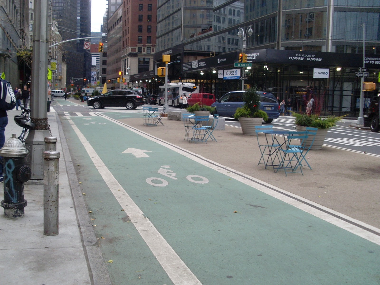
When I visited NYC last week, I specifically left myself some extra time to wander around looking at the city's new bicycle infrastructure. 200 new miles of bike lanes in the past three years, for over 1500 total lane-miles. Impressive, no?
Bike lane on Broadway
Well, yes and no. The infrastructure itself is first class. I mean, I am really jealous, and I wish we could get anything that looks like that in Atlanta! Many of the lanes used colored pavement to make them stand out. Most of them are buffered, at least at key points. A beautiful bicycle-only path loops most of the way around the island of Manhattan, offering views of waterfront parks, and the bridges have designated bicycle lanes separated from motorized traffic. Altogether, it forms a pretty comprehensive network until you get out toward the edges of the city.
Traversing the Williamsburg Bridge on a dedicated bike lane. The pedestrian route is on the opposite side, also elevated above traffic.
Newly installed buffered lane with bike signal and signage
Using the lane
Bicycle facilities on the Brooklyn Bridge
A separated path next to 11th Avenue
However, I saw very few bicyclists relative to the total volume of traffic. There are streets in Atlanta with more frequent bicycle traffic than many parts of Manhattan! The majority of the people I did see on bicycles were making deliveries - men transporting restaurant take-out and flower bouquets for low wages. There were also a handful of spandex-clad athletes, some groups of tourists on rented bikes around major attractions, and a smattering of hipsters and everyday folks on basic city bikes. Hardly anyone was riding in the bicycle lanes. A large percentage were riding the wrong way, against traffic, in either the general purpose lane or a bike lane. Some were on the sidewalk.
Empty delivery basket, traveling wrong-way in the bicycle lane
A woman rides against traffic on a quiet street
Rented bicycles near Times Square

Chinese food trumps traffic controls
What's going on? I suspect it is the local transportation "culture". Every city has one. NYC has a dominant pedestrian culture in which motorists tend to expect people to be in the street. They drive cautiously compared to other cities and are very good about yielding to pedestrians. People cross the street whenever there is a break in traffic, regardless of signals or pavement markings. It seems to be understood that pedestrian travel is an essential part of a functioning city. This was the only place I have ever been in America where I felt like drivers interacted with me person-to-person when I was on foot. This is good for bicyclists, because drivers are expecting to see people in the roadway and to be respectful towards them. It does have drawbacks, though, as pedestrians often take over bicycle lanes.
Annexed bike lane
Bells are required in NYC - and used frequently on the Brooklyn Bridge to shoo pedestrians out of the bike lane

There is also an issue of supply and demand. Central Park and the waterfront path were popular. These routes had few pedestrians and ample room. Better yet, they allowed cyclists to travel at full speed, bypassing the traffic signals and congestion on parallel streets. But they didn't go where the people on bicycles were trying to go. For the delivery guys trying to transport hot food a few blocks away, as fast as possible, it seemed most expedient to ride up the nearest street even if traffic was going the opposite way. With lots of one-way streets and few curb cuts, the bike lanes rarely took cyclists to the front door of their destination. Instead they used the closest lane, often on the opposite side of the street from the bicycle facility, and rode up the sidewalk from the corner. The unprotected bike lanes served little purpose at all, filled with delivery trucks and double-parked cars, and the rest of the traffic was moving at bicycle speed anyway. At the Brooklyn Bridge, a one-way vehicular ramp forced bicycle riders coming from lower Manhattan to make a large lap around the block to reach the bike route; most rode wrong-way up the ramp instead.
One-way access to the Brooklyn Bridge bike route
 Theft is clearly an issue, and bicycles of any apparent value were rare. The vintage steel frame bicycles that I love were fairly common, probably because they are cheap, less attractive to thieves, and come equipped for city riding with baskets and fenders. Pedicabs were available in a few places, but the prices were exorbitant relative to a taxicab ($20 for 15 minutes).
A riderless pedicab using a brand new lane

Here are my recommendation to Mayor Bloomberg, who I'm sure is reading this, and to transportation commissioner Janette Sadik-Khan:

New York City needs a bike share program! Transportation in NYC is all about flexibility - take the subway to work, then walk to a nearby restaurant to meet friends, share a taxi over to the Village, maybe catch the bus home. But if you ride a bicycle somewhere, you are stuck with it. If your friends are taking a cab, you have to ride and meet them, or leave the bicycle behind and hope you can come back for it later. With a bike share, that flexibility is restored. It can be substituted for any other mode without committing you for the rest of the day. Friends can spontaneously decide to cycle somewhere together. And theft is not a concern for the rider.

 I would also recommend buffered two-way bike lanes, contraflow lanes, and, where feasible, separated bicycle paths that give riders an advantage over traffic. They could also use official recognition of the bicycle delivery operators, and ask them what type of infrastructure they need - priority bicycle parking? They could also support pedicab expansion and freight distribution management.
The waterfront path

Tuesday, October 26, 2010

Who's the Bad Guy?

I just stumbled across a news article about a fatal bicycle-pedestrian crash on a trail in Dallas. A jogger, wearing earbuds, changed direction suddenly into the path of an oncoming bicycle. The impact knocked her to the ground and she sustained fatal head injuries. There was no mention of injuries to the bicycle rider or other details about the crash.

Going by the photos, the trail is a standard 12-foot path without any pavement markings. There is a pedestrian sidepath along some stretches. Local residents complain that the trail gets unbearably crowded at certain times of day.

Response to the incident has been a little bit rash. People identifying themselves as walkers, joggers, or bicyclists have been confronting each other at meetings and in the media. The trail managers have issued a long list of safety guidelines - such as 'stay to the right' and 'turn down volume on your headphones' - and are hosting safety classes. Many local leaders are calling for a 10 MPH speed limit for bicycles.

This gets to the heart of how we collectively understand bicycling and non-motorized facilities. First of all, imagine if someone hits and kills a pedestrian while driving their car on the road, with the pedestrian at fault. Would the speed limit on that road promptly be cut in half? Would all drivers be demonized? Not a bit. It would probably be ignored. If anything, they might put up warning signs or barricades for pedestrians. Not that I advocate restricting pedestrian access, but many of our traffic engineers do...

There was no information about the speed at which the bicycle was traveling with the crash occurred, so there are no grounds for saying that a speed limit would have prevented it. Even if you could enforce a speed limit. They have no laws governing bicycle or pedestrian operations on a trail, and thus no way to determine if someone is behaving unsafely - coming to close to other users, swerving/running into another user's path, or failing to control dogs or children. Did the jogger do something truly wrong by changing direction into the path of a bicyclist without looking? Should that action be illegal?

Although shared-use trails create a high potential for conflict between bicycle riders and people on foot, they are considered "safe" spaces where a single crash is unacceptable, even if you have to compromise convenience of use. On the street, we assume that crashes will happen and hesitate to impede vehicle flow to prevent them. Is this right?

Ultimately, the real fault here is the design of the trail. It has been way over capacity for years. If three feet is generally regarded as the safe passing distance at speed, how wide would the trail need to be to have two-way traffic with frequent passing? Bicycles need about 4 feet of operating width each, and pedestrians need 2.5 feet or more per person. Add children - in baby strollers and bike trailers - and you need even more space. And rollerbladers have a 9-foot operational width.

If the Katy Trail were a road, it probably would have been widened, or at least redesigned. But again, it was not held to the same standards as roads, leading to congestion and conflicts. Shooing cyclists off the path onto local streets isn't the answer either, unless your city has done a heck of a job making them bicycle-friendly. If the trail is popular, there is a reason for that. We shouldn't have to choose between unsafe trails and unpopular ones... So let's hope that America's trail engineers study this incident, and use it to create safer path designs with appropriate capacity for all their users.

Sunday, October 24, 2010

From Gap to Bump

A week or two ago, I wrote about a sinkhole on Spring Street. Now it looks like this...

Saturday, October 9, 2010

Mind the Gap

The Atlanta bicycle rider encounters certain hazards in her travels. Shoddy pavement, broken glass and nails, and misaligned sewer grates are common, not to mention Atlanta's notorious steel plates which are "temporarily" placed over work in progress. "Temporarily" can apparently mean "for months".

After enough years of abuse, local cyclists start to find ways to outsmart the bumps and hazards. Sprung saddles are much more effective than the front shocks of your average mountain bike, and they don't slow you down or add much weight. Steel-framed bicycles are heavier, but they provide a combination of strength and flex that you just won't get from aluminum (or carbon fiber, of course); the result is a feeling of smoothness rather than jarring or rattling. And wider tires absorb shock right at the pavement, while being less likely to get stuck in a gap or to rupture on a hard bump. Contrary to popular opinion, wide tires are not particularly slower than skinny ones; they can actually be faster on rough pavement because they transmit less vibration (vertical movement) to the frame and rider.

Anyway, I've been taking note of some of the most egregious holes and gaps. Maybe someday the city will put together a "bike hazard posse", like former Mayor Franklin's "pothole posse"?

The turn from Centennial Olympic Drive onto Baker has a tire-eating grate.
A deep but smallish sinkhole opened up in W. Peachtree Street... It takes up half a lane and has been there for over a month! 
A 3-inch gap on the Georgia Ave bicycle route. Be careful!
Garden-variety tire trap on Centennial Olympic Drive

Friday, September 10, 2010

Trails Survey

Please take this short online questionnaire about shared use paths and trails. With construction of the first "real" section of the BeltLine trail imminent, it is important to learn from the design of our existing paths and the experiences you have had on them. Thanks!

Friday, August 27, 2010

Atlanta's Magic Disappearing Bike Lanes

Getting bike lanes around here is like "two pedals forward, one pedal back". We've had on-street bicycle lanes removed on two street segments in the past couple of years, one replaced with sharrows and one replaced with a (much less safe or convenient) side path. Elsewhere, new lanes or sharrows have been added, but almost always with some sort of defect.

Exhibit 1 is the bicycle lanes on Fifth Street/Ferst Ave and on Ivan Allen Boulevard. Apparently, these lanes were marked with very low quality paint, that has completely worn off in the past year. Below is a photo of the lane on the Fifth Street bridge over I-75/85. You can see how worn the inner line is compared to the marking on the edge of the road, which is probably thermoplast. This section is actually in better shape than the blocks to the west, where you can't even tell that a bike lane ever existed!

Ivan Allen Boulevard is in the same condition, even though it is newer. You can barely see the markings at all. It's there, I swear. You might have to look really closely. Up near the delivery truck, which is parked in the lane, you can see a "bike lane ends" sign.

And now, the fate of this lane gets even weirder. The state DOT just finished reconstructing part of this street, from the top of this hill over to Northside Drive. And this project actually involved continuing the bike lane through the intersection and across the bridge to the Georgia Dome. They had to know it was there, but maybe the absent markings confused them. Because the reconstructed section on this side of the nearest intersection has no bicycle lane. The lane starts again on the opposite side of the intersection.

This means that the bike lane and the right-hand general purpose lane merge unexpectedly, without any signs or markings. This could create a really dangerous situation, since there is now warning and no way to determine who has the right of way. Sure enough, while I was stopped there taking pictures, a cyclist came along in the bike lane and an SUV approached in the right-hand lane. The cyclist (circled in the photo, and partly obscured by an aggressive crape myrtle tree) was only a few feet ahead of the car when they reached the point where the lanes merged. The car gave way to the cyclist (which was correct relative to their positions), but also swerved slightly into the left lane. Fortunately, there were no other cars nearby. The car then slowed down, merged behind the bicycle, and made a right turn.
The DOT is aware of the mistake, but it will probably take a very long time and some taxpayer dollars to fix. Hopefully the intersection will be repaired before there are any serious incidents. In the meantime, the City of Atlanta needs to inspect and restripe any faded bike lane markings on their streets.

Sunday, July 25, 2010

Parking - The Final Challenge

The bicycle infrastructure in Atlanta is seriously inadequate, but at least we know how we could fix it. There are good and bad examples from around the world. Not so with bicycle parking. Even cities that do a great job with bicycle traffic have very little on-street bike parking and never enough at high-demand sites, like train stations. Some cities are experimenting with giant bicycle parking decks, on barges, with valet service, or with automated racks that lift bicycles up onto tightly-fitted storage shelves.

Even with the small but growing amount of bicycling that we have now, it is clear that parking will be great challenge for Atlanta. Nearly every rack is full these days. City parking requirements for parking at new buildings are not enforced, and many of the racks that exist are poorly designed and in inconvenient or unsafe locations. What will we do if more and more people start riding?

Friday, June 18, 2010

Sharrows from Heaven

Sharrows have been mysteriously appearing around Atlanta.
Sharrow on Charles Allen Drive
Don't be alarmed. The sharrow is a bicycle rider's friend. Also called a "shared lane marking", the sharrow reminds motorists to expect bicycle traffic, and informs bicyclists where the safest lane position will be under normal traffic circumstances. For instance, sharrows can remind cyclists not to ride in the "door zone" of parked cars.

These aren't fake sharrows either, like the ones that somebody painted on Peachtree Street in the middle of the night a few years ago. These are the real deal, presumably painted by the City of Atlanta. The city finally feels comfortable using sharrows, now that they have been approved by the MUTCD (the Manual of Uniform Traffic Control Devices).

Basically, the MUTCD is a compendium of all the signs, pavement markings, traffic signals, and so forth, that have been approved for national usage, and their specifications. Most transportation departments will be reluctant to try any type of traffic control that hasn't been approved in this manual. Isn't transportation fun??

New sharrow on Georgia Ave next to Turner Field